Geographers have long wrestled with the problem of classifying and analyzing urban places. Such activity ultimately allows geographers to understand the processes by which the present urban patterns have evolved. For South Asia, they have attempted to apply mostly Western economic, functional, morphologic, and mathematical models to cities whose historical evolution, cultural connections, and economic and political structure are non-Western, for the most part.
Attempts by geographers to understand urban places embody several strategies which have been identified in the National Geography Standards.1 The use of mental maps, or descriptive models, aids in organizing information about cities (Standard #2). In the process, such models can be used to interpret the ways in which cities evolved to reach their present form (Standard #17). Throughout, geographers are searching to understand how and why urban places are arranged as they are, and what these patterns reveal about the functions performed within and by cities (Standard #12).
With regard to the morphology or physical form of South Asian cities, the difficulties are especially manifest. Land use patterns, transportation facilities, and residential neighborhood layout, for example, are at variance with Western urban experience. Hence, South Asian city patterns are not easily explained or satisfactorily elucidated by well-known Western urban morphology models, such as the concentric zone, wedge or sector, or even the multiple nuclei. These models in combination effectively explain the structure and land uses of Western cities. The lack of success in applying these models to non-Western cities is not because numerous attempts have not been made, but as Smailes noted, “assumptions and theories about city structure tend to be culture bound” and hence not especially applicable outside that culture.2
The few descriptive models which have been devised to explain South Asian city structure do not seem to have received widespread acceptance. An important element explaining this absence of adoption may be the lack of universality in their application to South Asian urban centers. For example, Manzoor Alam evolved a model to account for urban growth and structure in Hyderabad (Deccan).3 His model is clearly related to Western urban morphology models, especially to the concentric zone, but it does attempt to formulate, however tentatively, a new approach. However, Manzoor Alam did not intend to offer his model as a universal exemplar for South Asian cities.
Similarly well known is R. L. Singh’s work on Varanasi (Banares). Although he did not provide a model illustrating urban growth, he did identify “geographical zones” which have a roughly concentric pattern.4 The Banares cantonment, however, did not fit easily into his scheme. Subsequently, Singh did attempt to employ a model, drawing an analogy from the biological cell reproduction processes and results of histogenesis, pattern formation, morphogenesis, fibroblasts, and sarcomas.5 Needless to say, the system never caught on.
Further complicating the analysis of Indian urban structure is the long period over which Indian cities have evolved. It seems reasonable that even appropriate theories of morphology which apply to the early or medieval periods of Indian urban history would likely be inappropriate as explanations for modern city form. In fact, at least four very broad epochs of urban development in India can be perceived. Of these four periods, only two have received attention, albeit limited, from urban geographers.
The four periods are the Classical, from earliest settlement through Gupta times (up to 550 C.E.); the Medieval, from the Gupta empire through that of the Mughals (550 C.E. to 1700); the British colonial period, during which many Indian cities totally altered their form (about 1700–1947), and the modern period, after Independence and during which rapid population growth has forced modification of urban centers.
THE CLASSICAL PERIOD
The earliest period of urban development in the Indian subcontinent stretches back to prehistoric time. The urban centers of the early period of Indian history contain those cities in which the efforts of early planning can still be discerned. These cities follow a mandala form and are thus related in some fashion to the Hindu (or less often, Buddhist) religion. A mandala is a geometric representation or model of the cosmos.
The mandala as an influence in early Indian city planning has been extensively studied.6 In point of fact, the number of examples in south Asia in which mandalas can be attributed as sources of inspiration for town structure is small. The orthogonal structure of Indus Valley cities such as Mohenjodaro and Harappa is often seen as having a mandala influence, but these cities remain only in barest ruins today, and the connection is tenuous.
Only in the Kathmandu Valley to the north, in Madurai at almost the opposite extreme of south Asia, and possibly in Jaipur, have mandala influences been positively identified. The mandala basis of urban developments at Kathmandu, Patan, and Bhaktapur under the Hindu Malla dynasty after the twelfth century has been studied by Jan Pieper.7 In the Kathmandu Valley it is the relative positioning of the cities, as well as their internal form, which is a response to a mandala conception.
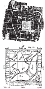
The great temple city of Madurai in south India is the best example of an existing city whose form is clearly the result of the application of mandala planning. “Enclosure and protection reinforces holiness, and the key movements are from the outside in, or circling the sacred enclosure in a clockwise direction”8 (Fig. 1). I remember clearly, when I first visited Madurai, how frustrated my attempts were to reach the centrally-positioned Meenakski Temple by following a straight line toward its clearly visible tall gateway. Only by following a circuitous route along the encircling ring streets was I finally able to find the entrance to the temple.
Jaipur, founded as late as the eighteenth century, also utilizes elements of classical Hindu mandalas. Sealey has recently examined the early planning and layout of the city.9 The mandala influence is not as clear as in Madurai.
citation)
THE MEDIEVAL PERIOD
Cities whose form originated in the Medieval Period fall into the well-known, pre-industrial pattern identified and described by Gideon Sjoberg. The basic characteristics are random and irregular arrangement of streets, extreme crowding with little open space, a small central bazaar or square around which are grouped the most important municipal buildings, and the residences of the wealthiest and most influential citizens. The fringes of the settlement shelter inhabitants having the lowest social ranking, who are often newly arrived from the countryside. Segregation of neighborhoods on the basis of occupation (and secondarily by other social characteristics) is pronounced because place of residence and place of work are in large part coincident. This is primarily a result of the low level of technological development reflected in the lack of mechanized transportation.
Indian cities which follow this model are the products of slow accretional and evolutionary growth over a long period of time. It is possible that some thought may have been given to the conscious planning of their original or early form, but very little or nothing remains of such initial effort. Before discussing models for the British Colonial Period, the main focus of this study, a few comments on the modern period are offered.
THE MODERN PERIOD
A few geographers have attempted to provide models to explain modern urban growth and development in India.10 One quite original attempt was a model proposed by Johnson, although it tended to include too much detail and hence failed to function successfully (Fig. 2). Spatial relationships were especially difficult to identify. The model also became too complex by attempting to explain the entire history of urbanization in India.
Alok Singh is one of the very few Indian geographers to examine the land use patterns of small cities and to attempt model building thereof. His models refer to modern, industrial, planned communities and thus apply only to a very restricted group of cities. They do not have much applicability to most Indian cities. Singh’s models have a marked concentric arrangement which is partly the result of the planning framework of the cities and probably partly the influence of the Western-city model.
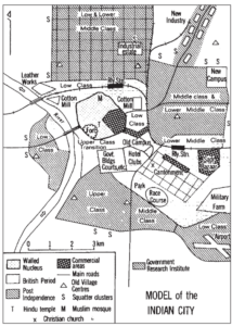
A Western influence can be seen in models proposed by Dutt in “Cities of South Asia.” He discusses two models: the bazaar-based city and the colonial-based city. He also suggests the possibility of a hybrid of the two. The bazaar city model seems to fit many modern Indian cities, but the colonial-based city model more properly belongs to an earlier period.
The bazaar city model is organized in a series of concentric zones, peripheral wedges, and cultural enclaves (Fig. 3). Thus, Dutt has nicely incorporated the three major Western approaches to urban morphology. Dutt’s model seems to be less effective than his perceptive description of the organization of the city. It is just this latter approach which I suggest can be employed most effectively in combination with a graphic model to discuss the Indian cities which emerged during the British Colonial period, and whose land use patterns can still be seen today.
THE BRITISH COLONIAL PERIOD
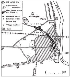
Dutt’s second urban model (Fig. 4), which he calls the Colonial-based city model, refers only to the largest cities; the Presidency towns (Bombay, Calcutta, and Madras), and perhaps a few other large cities. He does note three other urban forms which he identifies as Cantonment, Railway Colony, and Hill Station. The last of these represents a very unusual kind of settlement, performing a limited and very specific set of urban functions.11 The other two are much more common than the Hill Station and in fact are colonial-based cities. I believe they should be treated in general descriptive models for cities of this period.
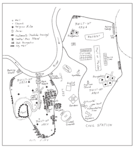
The earliest of the descriptive models of cities developing during the colonial period is that offered by Smailes (Fig. 5). Therein he effectively articulated the binary structure of a large number of Indian cities, pointing out the association of these urban places with administration, both civil and military, and with the network of railways built by the British in the nineteenth century. Again, Smailes’s description of the city is marvelously effective, drawing forth vivid word pictures of the typical urban place, but his diagram or graphic model conveys little to the reader of the interrelationships of morphological units within the city.
With these problems of the Smailes and Dutt models in mind, I have attempted to sketch a graphic model, or rather two models, to portray Indian urban places. To be effective a descriptive model should illustrate all the common, or mostly common, urban elements. It should not be too cluttered and should offer a clear idea of the spatial relationships of settlement features, but not necessarily the exact dimensions. Most desirable is a graphic treatment which uses both clearly recognizable symbols and visually specific signs. Abstractions, such as shaded patterns, should be avoided. It seems wise to use two models for India, which enables a clearer treatment of civil stations vs. cantonments as variants of the British-oriented settlement on the one hand, and fortress vs. temple dominated places as variants on the indigenous towns, on the other. Smailes has already pointed out the likelihood of needing regional subtypes of urban models, and my current ones do offer some differentiation which is based upon regional expression.
Used with permission from Heinemann Educational Publishers
(see list of references for citation)
MODEL NUMBER ONE
The dual nature of Indian cities formed during the colonial period is easily seen in this model (Fig. 6). In the native settlement, the fort, often located upon a steep eminence, is the dominant feature. A secondary focal point is a large temple, located close to water. A roadway, containing permanent shops and often a pavement bazaar, connects the two facilities. A serai, today the relict of an earlier travelers’ shelter, and the central bus stand, a late but increasingly important phenomenon of the colonial city, are features near the chawk, or main intersection, of the town.
The occurrence of water is of considerable significance in an environment where rains fall regularly for only four or five months a year. Thus, both the bathing ghats (for washing) and the burning ghats (for cremation) accrue a certain religious aura. The former is most likely to be centrally located, often close to the main temple. On the fringes of the bathing ghats, washing of both utensils and clothes normally takes place. The burning ghat typically will be downstream from the settlement and bathing ghat to reduce pollution.
Pucca (high quality) housing is organized into neighborhoods called mohallas, which frequently are segregated on the basis of caste or language. One of the most distinctive and well-known of the latter is the Bengali tola.12 Kachcha (poor qualitiy) housing is widely scattered in clusters of hutments throughout the town. The hutment settlement of Harijans (Untouchables) is likely to be just outside the precincts of the city. In some cases, these limits are marked by remnants of a city wall and perhaps even a moat.

The British contribution in this model of the Indian bipolar city is the Civil Station, a center for British residence and administration. Located at a convenient distance from the indigenous city and separated from it by an open area buffer zone, the structure of the Civil Station is quite different from the native settlement.
A wide, tree-lined mall or a rectangular, grassy maidan functions as the center point. Nearby is a large bazaar providing the retail services which the Civil Station requires. Each of the important administrative offices and facilities, including the Law Court, the Hospital, and the Anglican Church, has its building in the Civil Station, usually ensconced in a surrounding garden. The homes of the upper-level administrative officials, called bungalows in India, although they were often two-to-three story mansions, quite unlike houses called bungalows in the Western world, were similarly separated within walled garden compounds. Small houses and barracks-like apartment blocks are neatly arranged and segregated on the basis of employment. Thus, middle-level British employees of the administrative government offices occupy the area called Civil Lines, police are housed in Police Lines, and railway employees in Railway Lines. Another important feature of the Civil Station is the railway station, although by late nineteenth century railroads had usually been extended into the indigenous city.

for citation)
Hutment slums grew up at the periphery of the Civil Station to house those persons who provided menial services, or otherwise supported the settlement, but who did not have formal living quarters within the Civil Station as house servants did, for example.
Finally, the dak bungalow, or in large centers, the government guest house, functioned as a hotel of sorts for traveling officials, and sometimes other transient British. Variations of this facility might be termed the circuit house, the inspection bungalow, and the rest house.
The third major component of the bipolar Indian colonial city was the unnamed open space which effectively separated the other two areas. Left open, perhaps unconsciously as a symbolic separation of Indian and British ecumenes, the area did possess a number of recreational facilities which benefited from the openness of the area. The English Club, or a facility designated by some other variation, was oriented primarily to males, although its dining room, ballroom, and card rooms were open to ladies. It was often the temporary home of the newly-arrived, bachelor officials, and it sometimes rented rooms to British travelers. The botanical garden was often laid out as a formal English garden, but with plants native and conditioned to the climate of India. Only in the cooler climate of the Hill Stations could the true English garden be duplicated. The race course and the cricket ground were universally encountered. The gymkhana was a sports facility whose membership was restricted to British males. It featured squash, badminton and tennis courts, billiard and card rooms, and late in the Colonial Period, often a swimming pool. With the passage of time, some of the wealthier segments of various Indian communities in the larger cities established their own gymkhanas, to which membership was also restricted and closely regulated.
URBAN MODEL TWO
The second urban model for Indian colonial cities (Fig. 7) is more appropriate for Cantonments and temple or pilgrimage-oriented cities, the latter more often than not in southern India. In this model, the British and Indian cities are not so distinctly separated.
Used with permission
(see list of references for citation)
The focus of the Indian settlement is a major Hindu temple, but a secondary temple is also present. A ceremonial roadway for the periodic passage of the temple car connects the two religious centers. The most famous temple car is one associated with the temple of Jagganath in Orissa state. Weighing several tons, the huge car is pulled by hundreds of faithful devotees of the Hindu god Jagganath during festival celebrations. On slight down-slopes the enthusiasm of those pulling the car, the ineffectiveness of those holding the ropes behind to brake the car, and the car’s enormous weight sometimes combine in an irresistible rush forward of the car, placing those in front of the heavy wooden wheels in great peril. This circumstance provides the origin of the word juggernaut, i.e., an irresistible force.
Flanking the car street are substantial residences with elevated porches called pyols, from which an excellent view of religious processions is obtained. Even though natural water bodies provide the locus for bathing ghat and burning ground, a ceremonial tank abuts the main temple. If the temple functions as a place of pilgrimage, a dharmsala will be located fairly nearby.
This is a hall-like building, with a minimum of room partitions and no furniture, where pilgrims can rest, lay out their bedding at night, and cook modest meals. Also close by is a residential neighborhood called an agraharam, where Brahmin retainers of the temples have their residences. Ethnic neighborhoods and hutment areas, the latter called cheris in southern India, are similar to those of model one, with Harijans at the extremity of the town.
As city sizes increased, some differentiation of land use was encountered. Small groupings of godowns, workshops, and small factories arose. The godown, or warehouse, derives its Indian name from the Malay godong. King has commented upon the significance of the derivation of this word, as well as a parallel evolution of the word compound from Malay Kampong. He notes, “It is of some significance that two of the most fundamental functions belonging to an urban form of social and economic organization, namely, the division and enclosure of space for residential purposes and the provision made for storing a surplus product, are both designated by terms deriving from the economic and political process of colonialism. In a small but significant way the terms compound and godown indicate the impact which colonialization has made on urban development in the indigenous society.”13
By 1863, 114 Cantonments had been created by the British administration.14 In some instances, earlier forts of vanquished foes were occupied and, together with a surrounding territory, turned into a British military post. More often, however, the Cantonment was newly planned from the ground up for maximum military advantage.
The Cantonment is organized around a fort, surrounded by an open esplanade, which originally provided a clear field of fire for the fort’s guns. Another open area, the maidan, was organized as a parade ground. The different branches of the military were housed in apartment blocks and barracks, variously identified as artillery lines, infantry lines, and so on. Officers’ families occupied larger bungalows set in spacious, orderly compounds.
Drawn by M. Margaret Geib
British civilian personnel, who had no logical place in the Cantonment, were frequently found in an extension called European Town to differentiate it from the indigenous settlement which might be termed Indian or native town by the British. In some instances, the European extension was named after a prominent local British official or a businessman. The extensions were always physically close to the Cantonment, probably for psychological protection, yet they also sometimes occupied a symbolic position midway between the official British settlement and the indigenous town. Housing in the extensions resembled that in Cantonment, with bungalows within compounds predominating, but also with some blocks of flats.
CONCLUSION
Cities in India today do not fit Western morphological models very well, and geographers have not been totally successful in offering South Asian descriptive models to explain those urban patterns. Part of the problem is the basic complexity of the cities, whose form has evolved over an extended period of time. The British Colonial Period was one of the most important times because new city patterns were established during the British occupation, and these have persisted to the present time.
Two descriptive models are offered to identify the various urban components, to explain their functions, and to provide a rationale for their geographical relationship. The models proposed in this study combine symbolism with appropriate spatial relationships to interpret many features which, even though modified in some instances, continue to characterize the average Indian city.

Drawn by M. Margaret Geib
Formulating descriptive, as well as analytical, models is one of the techniques used by geographers to arrive at a more precise understanding of urban form. Such models offer not only an overall visual representation of the city, they also help explain why cities have developed as they have. In the process, it is often possible to clarify the relationships between different cultural and social groups, as well as to reveal the political and economic forces at work.
Earlier it was suggested that the use of the two descriptive urban models discussed in this article could provide a method to reach several of the goals of the National Geography Standards. As employed in this article, the models may be thought of as mental maps illustrating how many Indian cities evolved during the British colonial period. It must be emphasized that all urban places, and not just Indian cities, are in a process of constant change. Nevertheless, the form and structure evolved during the colonial period provide a base upon which later modifications have been executed.
In the final analysis, the examination of descriptive Indian urban models enables students to approach Standard #3 of the National Geography Standards (How to analyze the spatial organization of peoples, places and environments).
NOTES
1. Geography for Life: National Geography Standards (Washington, D.C.: National Geographic Research and Exploration, 1994).
2. Arthur E. Smailes, “The Indian City,” Geographische Zeitschrift 57: 177–90, 1969.
3. S. Manzoor Alam, Hyderabad-Secunderabad: Twin Cities, A Study in Urban Geography (New Delhi: Allied Publishers, 1965).
4. R. L. Singh, Banaras: A Study of Urban Geography (Banaras: Nand Kishore & Bros., 1955).
5. R. L. Singh, “Social Factors in Morphogenesis of Varansi: A Suggestion in Technique for Form Evaluation,” Urban Geography in Developing Countries (Varansi: The National Geographical Society of India, 1968), 3–27.
REFERENCES
Dutt, Ashok K. “Cities of South Asia” in Stanley Brunn and Jack F. Williams, eds. Cities of the World. New York: Harper and Row, 1983.
Johnson, B. L. C. India: Resources and Development. London: Heineman, 1979.
King, Anthony D. Colonial Urban Development: Culture, Social Power and the Environment. London: Routledge and Kegan Paul, 1976.
Singh, Alok K. “Typology and Structural Models of Urban Centres in South Mirzapur,” National Geographical Journal of India, 34: 3: 249–255, 1988. Sjoberg, Gideon. The Preindustrial City: Past and Present. New York: Free Press, 1956.
Smailes, Arthur E. “The Indian City,” Geographische Zeitschrift 57: 177-90, 1969.
USING URBAN MODELS IN THE CLASSROOM
The models in the article portray the Indian city as it was in the British colonial period. Several points stand out—the segregation of castes, the relegation of untouchables to the periphery, the separation of colonial and native areas, the importance of facilities associated with water use (the various ghats), the temple and the fort as centers of opposing power.
The number of films and videos on India is great, indeed. Unfortunately, few of them deal with the city except as a location or backdrop. Some of the better ones which provide at least a pictorial idea of Indian cities are listed below.
The Power of Place: Program 21: Urban and Rural Contrasts, 27 min., c. 1994
The Annenberg/CPB Collection
P.O. Box 2345
S. Burlington, VT 05407-2345
phone: 800-532-7637
fax: 802-864-9846
India Unveiled: Modern India, 30 min., c. 1986
Encyclopedia Britannica, Inc.
310 S. Michigan Ave.
Chicago, IL 60604
phone: 800-621-3900
fax: 800-344-9624
Tapoori: Children of Bombay, 26 min., c. 1994
Filmakers Library
124 E. 40th St.
New York, NY 10016
phone: 212-808-4980
fax: 212-808-4983
Village Man, City Man, 38 min., c. 1975
Center for South Asia
University of Wisconsin, Madison
1155 Observatory Dr. #203
Madison WI 53706
phone: (608) 262-4884
fax: (608) 265-3062