In the past twenty-five years, China has dramatically moved from a rural, agrarian economy and culture to become more urban and a major world economic and political force. In the process, key economic core areas have moved south and eastward, especially to the coast.
Historically, China was a country of small-scale intensive farmers (a “hoe culture”), divided by the physical limits of climate, hydrology, topography, distances, and a population dominated by family and elders in which Confucianism was usually the dominant belief system. Later, the Communist Party defined one’s future. These physical and social elements affected history, politics, dress, diet, architecture, demographics, and economics.1
The shift from doctrinaire communism to an emphasis on commerce and technology has helped the country overcome historic physical geographic limits. China’s modern geography and politics are increasingly defined by clusters of large cities, factories, modern technology, immense government wealth, and an increased percentage of youth—especially in its eastern and southern coastal regions.
The Chinese Empire formed and expanded from the region of modern Xi’an. Using wealth and technologies (such as horses, waterwheels, and chariots) from commerce, along what would later be known as the Silk Roads, the Qin dynasty (221-206 BCE) forcibly merged distinct geographic kingdoms to the east and south. Gradually, the focus of the empire moved east of the Taihang Shan mountain range that defines the North China Plain and the lower Huang He River. New capitals emerged at Luoyang and Kaifeng, but they still focused on trade and commerce associated with the Silk Road and markets and cultures of the West (Xi’an, the Gansu Corridor, and modern Central Asia). Initially, physical geography defined an empire composed of distinct east-west nodes with the Taihang Shan forming a natural border between east and west.2 Commerce and interactions with the West declined as the rise of Islam and other events created instability and destroyed or reoriented former markets and trading partners. Self-sufficient, China turned inward and reduced international trade. Society began to disparage merchants in favor of Confucian scholars.
New trade centers emerged in southeastern China (Lingnan) and along the east coast. Arab traders began to arrive in the eighth century; the Portuguese arrived in the sixteenth century and the British in the eighteenth century, creating important trading entrepots in Macau, Hong Kong, and Shanghai by the middle of the nineteenth century. These events gradually changed China’s economic and social geography. What had been China’s “back door” hinterland (the Pacific) now became its “front door” or foreland.3 The change was resisted and even ignored by leaders in the north. China had no need to trade with external markets—a point first made to the Portuguese and then to Lord Macartney in 1793 when he came seeking trading rights. The Opium Wars (1839–1842), Boxer Rebellion (1900), and Japanese Occupation (1937–1945) forced China’s leaders to recognize the need to place emphasis on China’s southern and eastern margins and focus less on the west and north.
The success of the Communist Party in 1949 created a temporary implosion of development, even a symbolic looking west (to the Soviet Union). However, the emergence of global maritime trade, expanding export-oriented manufacturing, the electronic age (TVs and the Internet), new cities, and city clusters asserted the dominance of eastern, especially southeastern, China. This geographic change was formally recognized and encouraged under the Seventh Five Year Plan (1986–1990) and the leadership of Deng Xiaoping. The decision was made to promote development and overseas investment in Special Economic Zones along the east coast. It was a recognition that China’s future lay in the east, with trade and manufacturing, not in autarky and isolation.4
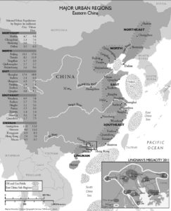
Geographic Regions of Eastern China
The national, political, and economic core area of eastern China remains the North China Plain (Huang He and Beijing). However, today eastern China functionally includes the lowlands of the northeast/Manchuria; the middle and lower Yangzi River; the cities and city clusters of Shanghai; Wuhan; and the cities of the southeast coast.
Rail lines have replaced the Grand Canal, once the main north-south link. However, there remain few ways to penetrate the interior directly from the coast, areas historically and physically isolated (peripheral) to the capital and national core. Today, to better link all regions to the national core, China has committed to massive investments in national expressways and high-speed rail (HSR) systems. Once completed, these networks will help integrate the various subregions and remote provinces and cities.5
Physical geography divides eastern China into five distinct subregions:
Northeast. The first heavy manufacturing center for all of China, the northeast remains important for airplane and HSR manufacturing and export, as well as supplies of natural resources—coal, iron ore, and oil. Key cities include Harbin, Changchun, and Shenyang. Their port is Dalian.
North China. Gulf of Bohai. Bounded by the Shandong peninsula on the south and the Dalian and Korean Peninsulas on the north, the North China Plain is its core. Here, the Huang (Yellow) and Liao Rivers empty into the sea. There are oil and natural gas fields offshore, but no good natural harbors except the rocky Shandong and Liaodong peninsulas. The port of Tianjin is the out-port for the Beijing-Tangshan-Tianjin industrial triangle. Tianjin, Tangshan, and Qinhuangdao are increasing their role in export-oriented manufacturing.
East China. The East China Sea, the Yellow Sea, and Shanghai. Marked by a cluster of large cities and dominated by Shanghai, this subregion extends from Hangzhou Bay north to the Shandong Peninsula and includes cities along the historic Grand Canal. The East China Sea is a shallow, emerging coastline with no natural harbors. There are extensive natural gas and oil reserves offshore. Already, there are conflicts with Japan and the Republic of Korea over their exploitation. Major coastal cities include Hangzhou, Shanghai, and Qingdao. There is also significant development inland along the former Grand Canal—Hefei; Bengbu; Xuzhou; and Jinan, route of the new HSR line from Beijing to Shanghai.
Southeast Coast. A “drowned” and mountainous coastline, this region has numerous rocky inlets and islands, but no hinterland. Historically inaccessible except by sea, it was a haven for pirates, its cities defined by international trade and migration, especially to Southeast Asia. Its location opposite Taiwan gives it a strategic importance that justifies massive infusions of money for modernization. Key cities include Wenzhou, Fuzhou, and Xiamen. The creation of a passenger-dedicated railway line (PDRL) HSR from Ningbo to Shenzhen and Hong Kong is a major engineering achievement, finally integrating the region internally and with the rest of China.
Figure 1: Map/schematic of the regions and HSR and offshore oil/gas. Map by University of Kansas Cartographic Services. T. White and L. James.
The almost universal availability and use of mobile phones and the Internet, growth in the percentage of youth, and the internal migration to cities create and define shifts in social and economic geography.
Lingnan and the South China Sea. This region includes clusters of large export-oriented manufacturing cities such as Guangzhou, Shenzhen, Dongguan, Zhuhai, and Hong Kong, as well as Hainan Island and the South China Sea. Even earlier than the Han dynasty (200 BCE to 200 CE), the region engaged in maritime trade, first via the West River and its canals and later as a center for coastal shipping and manufacturing. Today, it has significant naval bases that protect China’s interests in the rich natural resources of the area, especially oil and gas fields in the South China Sea and control of crucial sea routes around the Malay Peninsula.
China’s historic focus on the Silk Road, western land regions, and later the piedmont of the Taihang Shan precluded the need for a navy. China’s leaders largely ignored the coast, despite a history of trade and migration with Southeast Asia and the fifteenth-century maritime feats of Zheng He.6
Following “The 7th Five Year Plan for National Economic and Social Development of the People’s Republic of China, 1986-1990,” this changed dramatically. There was increased political, military, and economic emphasis on eastern and southeastern China and the creation of coastal special economic zones. In turn, this fostered growth of the People’s Liberation Army/Navy (PLAN). The increasing sophistication of the PLAN is considered defensive against threats from Taiwan and the US. The PLAN also is essential for protection of trade routes and offshore resources, as well as new energy and raw materials supply routes via the Indian Ocean and the South China Sea.
China’s new attention to its coastal-maritime geography has no historic policy precedent. No national planning ever focused on the sea in a positive way. Culturally and politically, the sea is China’s new frontier and geography yet to be defined. It will be a focus of attention and possibly political, economic, and military confrontations and struggles.
Engines of Change
Various factors have combined to create and support this change:
· The shift from a predominantly rural and farming population to an urban and manufacturing focus.
· Massive wealth that has been created by trade and consumer manufacturing for the world market such as low-cost, high-technology manufacturing and global exports (from clothing and computers to high-speed trains, solar, and wind-energy technologies, etc.).
· Changes in education and geo-demographics, especially computers, the Internet, mobile phones, and increased urbanization by migration and less emphasis on Confucianism and communist doctrine.
· Applied technology, such as high-speed communication (air, rail, land, manufacturing, mobile phones, and Internet).
· Massive government commitment to investment in modernization and advanced infrastructure.
Manufacturing and Trade
Because of its geographic remoteness from China’s traditional core areas and its links to foreign countries, Lingnan and its ports had long engaged in foreign trade. Its cities and people moved easily to manufacturing and exporting for European and American markets.
Merchants and private entrepreneurs, once looked down upon as a class, today help define government policies more than communism. Individuals are encouraged to be creative and to do things traditionally prohibited by communist doctrine, such as private businesses. Today, the private sector employs approximately 3/4 of the urban workforce and produces 2/3 of the country’s gross domestic product. Urban youth form a subclass of the very wealthy, demanding cars, houses, and lifestyles once beyond the imagination of even the emperor.7 However, many urban dwellers, especially migrants and rural youth, remain unemployed. Family and clan remain strong influences, especially in the coastal cities of the southeast. It is a time of rapid social, cultural, and geographic change.
From Hoe Culture to Factory Culture: Demographics, Migration, Urbanization, and Geographic Change
Historically, Chinese culture and economy were defined by small farms and intensive agriculture. Surplus food fed bureaucrats in the capital and a growing but proportionally small urban population. There was no equality in the quality of life between regions or between rural and urban populations.
In 2011, China’s population was 1.34 billion with an anticipated increase of 100 million by 2015. This increase alone nearly equals the population of Mexico and is twice the population of Spain. Today, China is largely urban and urban-focused. It is important to remember when discussing Chinese statistics that percentages are based upon a national base of 1.34 billion; thus, even a 1 percent increase (over thirteen million) is a huge number. The population of many Chinese villages is often greater than what many people in other countries would consider small cities. It is impossible to determine exactly how many people live in cities. Many migrants live with family or friends in distinct communities and are not listed in official records. This shift to cities is a process known as urbanization.
In 2010, China’s urban population was estimated at 46 percent of its total. Estimates are that the urban population will exceed rural population by 2015.8 A significant amount of this growth is in the east and southeast. In 2000, twenty-four of thirty top-ranked cities by Gross Domestic Product (GDP) were located in the eastern region.9
Much of this urbanization is due to internal migration, not natural increase. Urbanization creates a dramatic break with China’s traditional social fabric (parent-child and farm-village). Migrants (mostly youth) cluster in distinct city districts with those who share similar culture and dialects. The consequence is urban mosaics with migrant neighborhoods forming emotional, economic, and social foci. Another consequence is economic exploitation and serious social and environmental stresses. Urbanization does not mean that China will suddenly become First World. But, it is an essential step.
The almost universal availability and use of mobile phones and the Internet, growth in the percentage of youth, and the internal migration to cities create and define the shifts in social and economic geography. Mobile phones and the Internet permit urban and rural populations to communicate and maintain links—another form of urbanization. And, once completed, planned expressway HSR systems will allow physical communication as well, e.g., holidays and taking urban goods (especially clothing and electronics) and technical skills back for rural street-market sales and use.
China’s future now focuses on its eastern region, coastal cities, and factories, not on rural farms. Today, cities export goods to the rural areas just as rural areas once sent food to the cities.
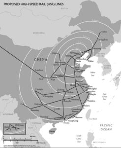
Figure 2: Proposed high-speed rail system. Map by University of Kansas Cartographic Services. T. White and L. James.
Integrating the Parts: High-Speed Transport Links China’s Parts
A continuing problem for China has been integrating its remote and peripheral provinces. Canals and highways were one solution, but they could not overcome the time required to move from one area to another. The planned expressways and HSR system, along with electronic communication, go far in addressing both of these problems, but differences will remain.
Benefits of high-speed transport will include:
· Links to remote areas will be speedy and efficient, not only for dispersed production and lower labor costs, but also for military control if necessary.
· Moving passengers to the HSR lines will free older lines for freight use, and because HSR are on raised pylons, farmland remains productive.
· Contracts and investments with foreign companies, many with new technologies and their related tooling, cost China virtually nothing to develop, and they can be exported.10
Transportation geographers use the concept of isochrones (lines of equal travel time) to illustrate the impact of various forms (modes) of transportation (rail, air, water, land). China’s planned HSR and expressway systems will dramatically reduce travel time to once largely inaccessible and peripheral areas.11 For example, missionary accounts from the 1930s depicted travel times from Burma to Kunming (close together on the map) as faster (and safer) by several months if people took a ship from Rangoon to Shanghai, a steamer up the Yangzi River, and then overland to Kunming from Chongqing. Even in modern times, the fastest and safest way to Lhasa is via Lanzhou, not Kunming or Chengdu. Although these cities look close on a map, they are separated by some of the world’s most difficult terrain—rugged and with massive changes in altitude, deep canyons, and raging rivers. Once, it took months to travel by land from Beijing to Urumqi in Xinjiang or even Kunming in the mountainous southwest. Now, it is a matter of hours.
Food Production: Feeding the Cities
Another major geographic change in China is food production and the increase in what are referred to as “market gardens.” Using modern technologies, including hothouses—the cost of which is offset by savings in transport and higher prices in the urban markets—even out-of-season foods can be delivered at a profit to concentrated populations. Improved transport and urban markets mean that even distant farms can produce specialized crops (e.g., wheat, meat, watermelons, other fruits and vegetables). As a result, many farmers are now getting rich.
As urban population increases, so does the demand for housing. The result is that agricultural land is lost. Importing food from neighboring (even distant) countries that produce a surplus is easiest in coastal cities where demand is greatest.12 However, coastal urban clusters increase China’s strategic vulnerability, which is another factor driving the expansion and geographic reach of China’s blue-water navy.
Mobile Phones and the Internet Overcome Geography and Regionalism
The challenges of distance and terrain become almost irrelevant as mobile phones and the Internet link even the most remote areas and isolated populations, thereby accelerating geographic and social change. Today, almost anyone in any place can communicate, coordinate, and do business. Sharing ideas allows even remote areas to participate almost instantaneously in events and developments wherever they occur. These changes have not reached all areas, but they are possible. Meanwhile, corruption, guanxi, or connections and “back door” deals remain endemic, often depressing opportunities for many youth, including college graduates. But their very numbers and urban migration remain important backup assets for China.
Most of China’s new leaders have advanced college degrees, primarily in engineering, and leaders no longer emerge only from the ranks of the political cadre. Equally important, China’s leaders are not limited by free market economics in what they can and are willing to do, e.g., construction of the Three Gorges Dam, water transfer projects from Tibet and central China to the north, expressway and HSR systems—none of which can be justified solely on profit/loss considerations.13
Another major change has been the development of what geographers call “footloose” manufacturing. This allows both concentration and strategic dispersal of crucial industries. Whether in high-tech manufacturing or sharing information and ideas, there often is no inherent advantage of being in one location or another. With computers and modern communication, there is no delay in the transmission of information or ideas because of distance. This is true for all aspects of the economy, from clothing fashions to architecture and economic or political directives from Beijing. Of course, this has opened China to the entire world—something the government tries to monitor and control.14
Some Consequences of the Shift
With key economic and development engines now concentrated in eastern China and its cities, China is compelled to defend this new geography. Defense justifies immense investments in technology, new factories, and the creation of a modern military. Today, China’s foreland and trade is maritime focused. This requires a sophisticated navy and air force with the ability to create a zone of military deniability to potential aggressors. China’s defense policy seeks to create a maritime “Great Wall.”15 To this end, the government has expanded China’s influence well beyond its domestic waters, including fleet visits to Turkey, anti- piracy patrols in the Indian Ocean, and visits to much of the eastern Pacific. It also means developing satellite and missile technology, as well as port agreements with countries around the Indian Ocean and even in the Americas.16
Just as the Qin Empire (221-206 BCE) benefited from overland commerce when China looked west, modern trade and technology have combined to make Eastern China and its cities, especially Shanghai, a new national focus. Historically, China’s geographic regions were defined by physical geography.17 Initially, it looked inward and focused along the piedmont of the Taihang Shan. Today, China’s political and economic geographies follow a north-south axis with subregions defined by large cities and maritime trade. The North China Plain, coastal cities, and industries of eastern and southeastern China now define multiple national core areas. Continued urbanization, the need to trade, and defense of this new foreland will define China’s actions for the near future.
9. Cities in China (Provincial and Prefectural Level) Gross Domestic Product per Capita: 2007, Demographia, last accessed November 8, 2010, http://www.demographia.com/db-chinacitygdp.pdf; see also Clayton Dube, “What are China’s Largest and Richest Cities?” University of Southern California, US-China Institute Online, last accessed November 8, 2010, http://china.usc.edu/.