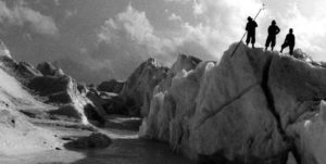
Pema Temba Sherpa climbed steadily up the snow-covered accumulation of loose rock, or scree. His destination was a rock cairn—an arrangement of stones constituting a marker—constructed by some mountaineer or scientist long ago in a remote region of Nepal’s Sagarmatha (Mt. Everest) National Park in eastern Nepal. Even at nearly 19,685 feet, the world’s highest mountains rose majestically around him for thousands of feet more on all sides, and made him feel small and vulnerable.
Pema was born in the Everest region, a member of the Sherpa ethnic group famous for its mountaineering skills. Although he had summitted Everest twice in his former career as a climbing sherpa, the light snow from the night before made what would normally have been a simple scramble a slippery and dangerous technical climb. Having neither a rope nor climbing equipment that day, a slip would have sent both of us plummeting thousands of meters to our deaths on the glaciers, boulders, and scree slopes below.
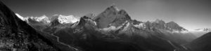
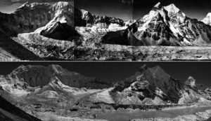
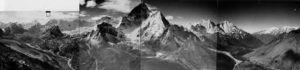
Realizing that it would be foolhardy to proceed under these conditions, I called out to Pema to stop, that this point and altitude (just 328 feet below the cairn) were good enough for the objectives at hand. Those objectives included the replication of a panoramic photograph taken of the Imja Glacier below us by climber-cartographer, Erwin Schneider in 1956. The cairn was a landmark that he had constructed to designate the location of his photo point.
Even though we were unable to stand at the exact point where Schneider’s photograph was taken, our view of the glacier and surrounding ice-clad peaks was unobstructed. Looking at the old photograph (Figure 1)—and then the view in front of me (Figure 2)—it was clear that something was dramatically different from the scene that greeted Schneider nearly sixty years ago. The Imja Glacier that I had hoped to re-photograph was gone, replaced by a lake about 3,281 feet long and 1,640 feet wide, holding millions of cubic feet of water. Boat to house-sized icebergs that had broken off from the remaining glacier terminus floated aimlessly in the water. Between Schneider’s cartographic expeditions (1956 to 1961) and my climate change research in 2007, the glacier had melted and left behind a large and potentially dangerous lake in its place.
Climate Change and Mountains
Global climatic change during the twentieth century has had a tremendous impact on the world’s mountain glaciers, particularly in the form of glacial recession and/or disappearance. According to the World Glacier Monitoring Service (WGMS), glaciers are now shrinking three times faster than they were in 1980. As many of the larger glaciers have melted, thousands of new glacial lakes such as Imja Lake have been created. These potentially dangerous lakes are often dammed by terminal moraines composed of loose boulders and soil that present an increased risk of glacial lake outburst floods (GLOF) in the event of a catalytic event such as ice avalanches, earthquakes, or natural dams breaching. The resultant floods can cause enormous devastation downstream including high death tolls and the destruction of valuable forests, farms, and costly infrastructure. In fact, a three-day walk to the east of us was the site of a GLOF that occurred in 1985 and destroyed a nearly complete $2 million hydroelectric facility, as well as bridges and lower altitude cropland more than sixty-two miles downstream. Fortunately, most of the local Sherpa people were at the higher altitude villages attending a religious celebration, so that the loss of life was limited.
Likewise, glaciers in the Hindu Kush-Himalaya cover over 20,505 square miles, a water equivalent to Lake Superior. Ten of Asia’s major rivers depend on their water supply in some way through geographically varying snow and ice melt. For the monsoon-fed Bramaputra River, for example, it is estimated that only twelve percent of the river’s water is derived from snow and ice melt, while the Indus River, in the dryer western regions of India and Pakistan, depends on snow and ice for fifty percent of its water. These figures are only estimates, and more work is needed to quantify the relative contributions of groundwater, precipitation, snow, and ice melt to Asia’s river systems. Nevertheless, the fact that Himalayan glaciers are receding is cause for concern since future water supplies stand to be affected in one way or the other.
In 2007 and again in 2008, Pema Sherpa and I spent approximately seventy-five days documenting these changes throughout the Sagarmatha (Everest) National Park of eastern Nepal. I was interested in learning more about the impacts of climate change on the world’s highest mountains from the perspectives of early climber-scientists such as Schneider, retracing their footsteps, and climbing to the high passes and cairns they left behind as a record of their journeys. My methods included repeat photography, remote sensing (i.e., comparing old and new satellite images and aerial photos), formal interviews, and casual conversations with the local Sherpa farmers, climbing guides, trekking guides, yak herders, and tourist lodge owners I encountered while trekking from one photo point to the other.
The Early Climber-Scientists
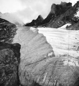
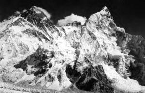
The previous year my advisor and mentor in graduate school, Professor Jack Ives, had given me a box of old photographs collected by his friend and colleague Professor Fritz Müller. Müller, a Swiss-Canadian glaciologist, was the Scientific Team Leader of the 1956 Swiss Everest expedition, and when the climbers went home, he stayed on for an additional nine months, living the entire time above 16,000 feet (a high altitude record at the time), studying the region’s glaciers with his Sherpa assistants (Figure 3). Over time, I was to discover that the box, in addition to its notes, rock rubbings, pressed plants, and letters, also contained photographs of two other noted climber-scientists, Sir Charles Evans and Erwin Schneider.
Evans was the Deputy Director of the 1953 British expedition that successfully put the first humans on the summit of Everest—Edmund Hillary and Tenzing Norgay. On a reconnaissance climb with his partner Tom Bourdillon, Evans was told by expedition leader John Hunt to go for the summit if the chance presented itself. In fact, Evans and Bourdillon climbed to within 800 feet of the summit when the oxygen system carried by Evans failed. While the team could have pushed on and possibly claimed the title of first men to climb Everest, the risk that such a move would pose to the expedition in the event of an accident or illness was considered counter to the team’s goals. They descended, becoming part of what is now remembered as one of the best examples of teamwork and success ever documented for an expedition (the majority of which ended in failure because of a lack of teamwork, poor leadership, and other factors). The 1953 expedition was the last chance the British had to claim the honor.
Despite enjoying a monopoly on the mountain since the late 1880s, Nepal recently had established a permit and payment system, and the following season’s slot would again be taken by the Swiss who, with Tenzing Norgay, had nearly reached the summit in 1952. Hillary and Tenzing summitted several days later and became instant legends. Evans remained behind for six months conducting glaciological research. He succeeded in making the first ascent of Kangchendzunga (about 27,730 feet) in 1956, although he agreed with the government of India not to traverse the actual top of the sacred summit. Evans was knighted in 1970 for a distinguished career in education and mountaineering.
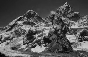
Erwin Schneider had been one of Austria’s top alpinists in the 1930s when he joined the German-Austrian Climbing-Cartographic Expeditions to the Cordillera Blanca and Huayhuash in Peru, putting up many first ascents, creating beautiful maps still in use today, and taking hundreds of photographs of the glaciers and mountain landscapes of both ranges. Many of his photographs of the Everest region that I used had been taken by Schneider, taped together to form beautiful black and white panoramas ( Figure 4).
While a number of glacier inventories had been conducted, and several scientific papers on the impacts of climate change in the Everest region had been published, all had been accomplished using satellite images as the primary data source, and virtually no concurrent on-the-ground field studies had been conducted. This struck me as odd, given all the media statements being made at the time about the impacts of climate change in the Everest region, none of which, it turned out, were based on actual field work and collaboration with local people. It thus became even more important to retrace the footsteps of Evans, Müller, and Schneider, climbing up and over the glaciers to their photo points just as they had done nearly sixty years ago, something impossible for a satellite or airplane.
Changes
Finding the original photo points was the first challenge as there were no Geographical Positioning Systems (GPS) when Müller, Schneider, and Evans took their photographs, and no records of their geographical coordinates were known to exist. We were usually able to find most of the photo points through a combination of our own familiarity with the landscapes, the suggestions of climbing guides and yak herders, and luck (although some photo points still have me mystified). The golden rule for finding the exact photo point locations—especially for Erwin Schneider—was to “always go higher than you think they went.” But several locations proved impossible to get to because of climate-related changes that had occurred in the interim, such as massive ice avalanches blocking the original trail, or glaciers that—while solid and healthy in Müller’s day—were now melting rapidly and hazardous to climb.
Receding glaciers and new glacial lakes were not the only changes I encountered and studied over the next several weeks, as a range of phenomena were in progress, most impossible to detect by remote sensing alone. We determined that the Imja Glacier had melted so rapidly because it had been covered by a thin layer—one or two meters—of soil and rocks (a “debris-covered glacier”) that would heat up during the day, then transfer the heat directly to the ice below. Glaciers become debris-covered when they begin to stagnate and cease their forward movement. Such has been the case in the Everest region since the end of the “Little Ice Age” in the late 1800s. Over time, boulders, rocks, soil, and other debris from the valley and lateral moraine sides cascade downward and cover the ice, in varying thicknesses. Most other glaciers in the Everest region, however, contain a very thick cover of debris, some with boulders the size of small houses that have tended to insulate them from the sun’s heat. These glaciers have nevertheless ablated, or lost mass over the years, as evidenced by the abundance of new, small, melt-water ponds on their surface and loss of any clean glacier ice that happened to be exposed. Likewise, hundreds of smaller, lower altitude “clean glaciers” with no debris cover had either lost most of their mass in the interim or had melted away entirely.
Ice above 23,000 feet, however, appeared to be remaining relatively stable, since at these high elevations they remain below freezing for most of the year. High elevation ice and glaciers with north-facing aspects had changed little, although warmer south-facing aspects tended to show more signs of melting and loss of ice.
In summary, I discovered first-hand that change was indeed occurring, even in the world’s highest mountains. Glaciers are melting, new lakes are forming, snowlines are ascending to higher altitudes, and weather patterns are becoming more unpredictable. There is growing concern for the impacts of these changes on future water supplies in the Hindu Kush-Himalaya region, as well as the increased likelihood of glacial lake outburst floods. Complicating matters, the media and a number of irresponsible scientists have promoted a “doom and gloom” approach to climate change for the past decade, making outrageous statements such as “all Himalayan glaciers will be gone by 2035,” which was recently acknowledged by the International Panel on Climate Change (IPCC) to be based on unsubstantiated research. Additionally, some 2002 press releases claimed that certain glaciers in my study region had receded by nearly 2.5 miles in the last fifty years when my photographs clearly showed this was not the case (remember, the glaciers had noticeably ablated, but they had not receded—yet).
There are so many challenges facing us today relating to climate change that overstating claims and grandstanding do nothing to help and can potentially cause much damage in efforts to combat the negative impacts of climate change. By far the more important question is, what can we as educators, scientists, practitioners, and students do about it?
Association for Comparative Alpine Research, Munich. Archives of Alton Byers.
Buffering the Impacts of Climate Change
Two years ago, I was talking with the director of our Andean Programs, Dr. Jorge Recharte, about creating a climate change initiative within The Mountain Institute, one that could focus specifically on the problems encountered by mountain people and ecosystems at our project sites in the Andes, Himalaya, and Appalachian mountains. We were having the discussion in the city of Huaraz, altitude 10,000 feet, an economic and tourist hub sprawled out beneath the beautiful ice-clad summits of the Cordillera Blanca (White Mountain Range) in Peru, location of the Huascarán National Park. The region has also been plagued since the 1940s by periodic and catastrophic glacial lake outburst floods, earthquakes, and debris flows, killing thousands of people at a time. The most recent glacial lake flood occurred in April 2010. Because the government of Peru took action and began controlling these lakes in the 1950s, the Cordillera Blanca was the perfect place to learn from experience that, in turn, could help us plan for a more resilient future.
The regular blending of the best of old school, muddy boots field geography with new school Geographic Information System (GIS) and lab based analyses is greatly needed.
We first agreed on three things: One, that we did not want to simply re-package the conservation and sustainable community development work we had been doing for decades and then call it climate change, a popular trend among other organizations at the time. Two, that we had to select areas that were within our sphere of influence to change (e.g., promoting local mountain conservation instead of trying to control the greenhouse gases of China or India). Three, that our final portfolio must consist of a few things that we, as a mountain-based and focused non-profit organization, could do well and in which we could make a difference. Our final list, whose activities I’m pleased to report are now under full implementation thanks to a grant from the US Agency for International development (USAID), consisted of the following:
Education and Awareness Building. Through photo exhibits, development of new climate change lesson plans, and educational materials, TMI is attempting to make a difference in people’s understanding, not only of climate change impacts, but also of the things that they can proactively do to make a difference, including:1
Conservation—Healthy, forested ecosystems cool the environment by up to 10oF (proof: stand in a clear cut in August for five minutes, then step into the forest), promote higher biodiversity, provide niches for more vulnerable plants and animals to migrate, and intercept and store precipitation in the form of groundwater, like a sponge. Cut down all the trees, impact the soil, and you have a landscape similar to a shale slate, promoting heavier runoff, floods, and river sedimentation, such as the catastrophic floods that destroyed the lower Potomac River in the 1930s following the complete deforestation of West Virginia by logging companies. The Mountain Institute considers this an especially important activity, since eighty percent of the world’s population in some way depends on water that originates in the mountains. As a result, we have implemented conservation and restoration projects throughout the world, from the mountains of West Virginia, to the paramos (high altitude wetlands) and Polylepis forests (the world’s highest growing trees) of the Andes, to the high alpine zones of the Everest region.
Dialogue—Scientists rarely speak to policymakers, and policymakers rarely speak to field practitioners. Bridging these communication gaps is always challenging, and in 2009 The Mountain Institute hosted an international, interdisciplinary workshop in Lima and Huaraz, Peru entitled “Adapting to a World without Glaciers: Realities, Challenges, and Actions.”2 The workshop gathered international scientists, policymakers, and practitioners to examine the impacts of glacier recession caused by contemporary climate change, and to identify priority research, collaboration, and pilot project initiatives. Activities included the presentation of papers (social and physical sciences); field trips to local glaciers, glacial lake control projects, and catastrophic event sites; training in the “Vulnerable and Adaptation Approach” to climate change resilience building (USAID 2007); and the development of key recommendations within the water, biodiversity, and agricultural sectors that were formally presented to government officials in Lima on the last day.3 Another distinguishing feature was that, as previously noted, several of the key recommendations from the workshop, specifically within the resilience building, watershed conservation, and educational sectors, are now being actively implemented by TMI in Peru. A second workshop, to be held in the Hindu Kush-Himalaya (HKH) region in 2011, is now being planned (see “South-South Collaboration and Exchange” section below), this time focusing on collaboration and experience exchange between Andean and HKH scientists, graduate students, and local people.
Resilience Building— In Peru we recently initiated the first of a series of training sessions for local people designed to build their resilience to climate change using a method referred to as the “Vulnerability and Adaptation Approach,” developed by USAID and partners as a tool of use to field practitioners such as The Mountain Institute. The method uses a six-step approach to identify a community’s assets; degree of exposure, sensitivity, and vulnerability; range of possible options available to mitigate or adapt to changes affecting the assets; selection and testing of options; and regular employment of the option selected. Working with villagers in selected communities, The Mountain Institute recently initiated training in Peru—some of the first of its kind in the world—and the entire process is expected to take about twelve months. However, the amount of learning and information that will be generated is expected to be enormous.
Interdisciplinary, Field-Based Research—Modeling and remote sensing are powerful and useful tools to have in the toolkit, but used alone they can often result in misleading results or interpretations. When combined with the best of the field-based physical and social sciences, however, a field scientist will be in the best position to understand more fully the phenomena being observed—new glacial lakes, decreases in water supply, increases in water supply—as well as a range of prospective solutions that may be available. As scientists and educators, we need to promote these fieldwork values among our students, as the trend of the past decade is to have students spend less time in the outdoors and more time before a computer screen. The regular blending of the best of old school, muddy boots field geography with new school Geographic Information System (GIS) and lab-based analyses is greatly needed. This is particularly true for the social sciences, since despite all the billions of dollars spent each year on climate change workshops and seminars, little, if any, research has been done with the participation of local people. Local people are already adapting to climate change, and they have a lot to teach us if we can somehow manage to shift the focus from the laboratory to the field.
South-South Collaboration and Exchange—Although Nepal has only recently begun to grapple with the problem of increased glacial lake outburst floods, Peru has been dealing effectively with the issue since the 1940s. In 1941, a glacial lake outburst above Huaraz killed over 5,000 people, and two more outbursts between then and 1950 killed an additional 6,000 people. In response, the government of Peru established a special Glaciology Unit that, without foreign assistance of any kind, controlled thirty-five dangerous lakes by fortifying their terminal moraines, draining the lakes with canals, or using more sophisticated engineering methods that not only controlled the lake, but also made use of the water for hydropower generation and irrigation downstream. Because this accumulated knowledge and experience has never been adequately captured and shared, The Mountain Institute and partners will host their second interdisciplinary workshop in Nepal in 2011, Adapting to a Changing Mountain World: Promoting South-South Knowledge Exchange and Collaboration between Practitioners from the Hindu Kush-Himalaya and Andes Mountains. Here, Andean scientists and field practitioners will share experiences with their colleagues from the Hindu Kush-Himalaya in water as a resource, water as a threat, and the human dimensions of climate change, including a two-week field trip to Imja Lake. Developing countries throughout the world have much to share with one another, and the resultant synergies may help find solutions to many of the challenges increasingly facing mountain people and environments worldwide.
Mountain Institute.
Conclusion
People are often surprised to hear that the world’s high mountains, ice-clad, unbelievably massive, and seemingly indestructible, are among the more fragile and sensitive landscapes in the world. Slopes are steep, soils are thin, climates are harsh, and even minor disturbances can take decades to heal. Because of their slope, aspect, verticality, mass, and altitude, mountains are also particularly sensitive to changes in climate. Mountains are perhaps some of the best natural barometers and predictors of the consequences of global climate change. As we have seen in this essay, not even the world’s highest mountains are immune to the effects of global warming. There is no better indicator of climate change than a receding or disappearing glacier.
In the 1950s, Evans, Müller, and Schneider were probably more concerned about the possible return of a “Little Ice Age” in the Everest region than they were about the (then) highly unlikely possibility of a warming trend and melting glaciers. They would most likely be shocked if they could see what actually has happened in the interim (Figure 5), but they probably also would be quick to say something along the lines of, “Yah, things are changing, now what do we do about it?” That is precisely the attitude we as educators, scientists, and students need to adopt and champion as well.
NOTES
1. Himalaya ~ Changing Landscapes is a climate-change photo exhibit that toured six cities in Europe during 2008 and 2009. The exhibit was created through a partnership between The Mountain Institute and the International Centre for Integrated Mountain Development (ICIMOD) in Kathmandu, Nepal, online at http://www.changing-landscapes.com.
2. “Adapting to a World without Glaciers: Realities, Challenges and Actions”, Workshop Proceedings, The Mountain Institute Report on the International Conference at http://www.mountain.org/press/events/glaciers/15%20Feb%202010%20Final%20English.pdf.
3. United States Agency for International Development, Adapting to Climate Variability and Change, A Guidance Manual for Development Planning, August 2007, online at http://www.usaid.gov/our_work/environment/climate/docs/reports/cc_vamanual.pdf.