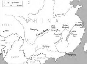
What we know as the Yangtze River the Chinese call the Chang Jiang, or Long River. As China’s longest river, the Chang Jiang plays a major role in shaping the country’s physical, cultural, and economic character. Its headwaters are in the rugged Tibetan and Qinghai Plateaus in western China, and flow eastward for 6,300 kilometers before reaching the sea near Shanghai (Fig. 1). Its watershed covers 18,000,000 square kilometers—about twenty percent of the total land area of China. Transportation along the Chang Jiang is a key factor in the development of large industrial cities along its banks. They include Chongqing, the largest city along the upper section of the river, and Nanjing and Shanghai along the lower section. Other regional economic centers along the Chang Jiang and its larger tributaries are Wuhan, Changsha, and Nanchang—all provincial capitals.

The lower section of the Chang Jiang valley is at the center of China’s rice growing region and includes much of the country’s most productive farmland. The broad floodplains along this section of the river and its tributaries have rich bottomland soil and abundant water. The fertile alluvial plains and humid, sub-tropical climate of southern China makes this region ideal for cultivation. Seventy percent of China’s total agricultural production and forty percent of its grain output comes from this watershed. Over the past few centuries, the region has become densely populated, and now more than 400 million people, or about one-third of China’s population, live within the watershed, fully half of them in the floodplain itself.1
Severe flooding along the Chang Jiang has been documented for nearly 2,000 years. While levees have been used to protect against floods since large-scale settlement began, in many cases they failed due to poor construction and maintenance. Despite the relative wealth of this region compared to other areas of China, flooding has caused extensive loss of life, as well as agricultural loss, and severe damage to cities and many small villages. Since the 1950s, levees have been greatly improved and expanded along this section of the river. Unfortunately, however, the frequency of extreme flood events has increased during the past few decades, and there have been catastrophic levee failures.2
The Chinese government has implemented aggressive flood control policies during the past few decades, but the potential for severe floods still exists. The purpose of this article is to provide a regional overview of the Chang Jiang basin, to describe the flood history of the Chang Jiang (including the most severe floods occurring since the mid1800s) and to discuss future flood risk.
REGIONAL OVERVIEW: GEOGRAPHY AND CLIMATE
The Chang Jiang watershed can be divided into two sections based on landscape characteristics. The upper river basin is in mountainous western China. At its source in the Kunlun Mountains, the river is about 6,600 meters above sea level. It flows through the sparsely populated Tibetan plateau, fed by disappearing glaciers and snowmelt. The river eventually drops off the Tibetan Plateau and flows through deep gorges in southwestern China. As it continues downstream, it joins several major tributaries before eventually emerging from the Three Gorges, currently the most famous section of the river. Major streams in the upper watershed have cut deep valleys that have little or no floodplain. Floodwater is restricted to the narrow valley bottoms, so even the most severe floods in this region have a minor impact.
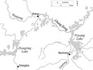
In contrast to upper sections of the river basin, the lower section, downstream of the Three Gorges, is surrounded by broad floodplains created by river meandering. In some areas, the floodplains extend many kilometers from the river channel before reaching surrounding terraces and hills. These alluvial plains are generally flat and flood during the wet summer season. This region is tectonically active where the Pacific Plate subducts (a geologic process that occurs when one edge of a crustal plate is forced below the edge of another) the Eurasian Plate. This uneven response of the earth’s crust led to the creation of several large lakes (Fig. 2). Poyang Lake in Jiangxi Province is the largest in China, covering 4,000 square kilometers during the wet season. Dongting Lake, located upstream in Hunan Province, is only slightly smaller. These and other large lakes along the lower section of the watershed drain into the Chang Jiang, but, during the past century, they have been shrinking rapidly in size and volume. This is partly due to sediment transported by rivers that fill these low-lying basins, but the primary reason for the loss of lake area is agricultural encroachment into the shallow lake margins and levee construction that protects them against floods. This loss of lake area reduces floodwater storage and has contributed to the increasing severity of floods, particularly during the past few decades. In addition, large tributaries that join the Chang Jiang along its lower section greatly increase the size of the river as it flows downstream.
Construction of the Three Gorges Dam, currently near completion on the Chang Jiang upstream from Yichang, will be the largest dam in the world and could influence flood risk downstream. In the late spring and early summer, the reservoir will be lowered to increase discharge, thereby increasing storage capacity. During July and August, when severe floods usually occur, water will be held back, reducing the risk of moderate floods downstream. However, the reservoir lacks the capacity to hold enough water to prevent severe late summer floods, such as the one in 1998.3
Southern China has a subtropical climate that is similar to the southeastern United States—short, mild winters, hot summers, and a long growing season. The rainy season typically begins in the spring when southerly monsoon winds move warm, humid air masses inland. These air masses encounter cold air from arid central Asia and are lifted along a stationary front, thereby causing abundant rainfall that increases the water level of the Chang Jiang and its major tributaries during spring and summer. El Nino year events nearly always cause more widespread and persistent rains in the region than non-El Nino years.
LEVEES
Without levees to protect against yearly floods, most of the Chang Jiang valley would be uninhabitable. The first levees were built along the main channel at least 2,300 years ago, and as the population along the watershed increased, new levees were constructed to separate progressively larger areas of the floodplain from the river. Extensive levee systems were eventually developed to protect even the lowest areas along the rivers and lakes—areas that otherwise would be submerged during summer. There are now about 30,000 kilometers of levees along the lower sections of the Chang Jiang—including those along the main channel and lower sections of its tributaries and at the shores of lakes within the floodplain.
Prior to 1950, poor levee design and insufficient levee height weakened the region’s ability to withstand severe flooding. In many cases, soil used in levee construction was not compacted, foundations were not properly prepared to withstand water infiltration, maintenance was inconsistent, and levees occasionally were excavated for building construction or other purposes. Breaches that occurred following bank erosion weakened levees, and water infiltration or movement through the base caused them to settle and eventually collapse.4 Since the 1950s, however, there have been significant improvements in levee construction. Levees have become taller and stronger—typically eight to ten meters above the surrounding floodplain—and levee failures are much less common, although they still occurred during the most recent flooding in the 1990s.
FLOOD HISTORY
In 1865, the first hydrology recording station was established at Hankou, in the middle section of the Chang Jiang watershed. Prior to 1865, river hydrology data was not collected; however, there are multiple sources on flooding information that date back centuries. Stone monuments and descriptive carvings have been found at dozens of sites, and many temples and religious sites have plaque and wall inscriptions that describe floods. Historical works and government documents include many accounts of flooding over the past two millennia. Although the earliest descriptions of floods may lack detail, historical sources enabled reconstruction of a reliable flood history for the past few centuries.
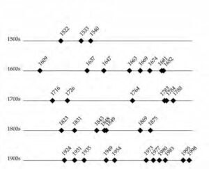
One flood chronology, created for the Chang Jiang near the mouth of Poyang Lake, was reconstructed for the five centuries between 1500 and 2006. Major flood year documentation was based upon primary sources describing the extent and depth of floodwater in cities. This chronology indicated fifty-four severe floods during the period—about one every ten years—and although severe floods occurred during every century, the frequency increased during the twentieth century, with even greater frequency since the 1950s (Fig. 3). Most of the severe floods occurring at the mouth of Poyang Lake had widespread effects along the lower Chang Jiang.5
Levees built before the 1950s offered adequate protection against normal high water, but were inadequate to protect against major flooding. Extensive alluvial plains along the river were almost completely flat, so when levees failed there was no high ground (except for the tops of levees) to provide refuge. One government official’s county report described conditions following the 1849 flood, noting that “most villages were abandoned; many people drowned, many people fled, and I do not know where they went.”6 Another report from the same region and time stated that
At the beginning of the flood, temporary huts were built on high ground, but eventually these areas were also submerged . . . with some people either holding onto a log or on a raft and drifting with the waves.7
Regardless of flood risk, people still choose to settle in the farming villages and small towns common in river floodplains (Fig. 4). The population continues to increase, and nearly 200 million people now live within the floodplain of the Chang Jiang and its tributaries. For those living there, the rewards of farming in this highly productive agricultural region outweigh the risk of losing income during summer floods.
Many examples exist of small farmers who live on highly susceptible river islands or low-lying areas and refuse to leave, even after repeated floods and levee failures. Jiangxinzhou, one of the largest islands in the Chang Jiang, covers about seventy-six square kilometers and is located within an enclosed levee that protects nearly 40,000 people who live there, mostly farmers and their families. Flood-related emigration from Jiangxinzhou and other low-lying areas is low—due in part to levee improvements and their increased confidence they will be able to withstand floods. Floodwaters have overtopped the levee at least twice since the 1960s. Both times, the only dry land available was the tops of the levees. Historical ties to the land and an uncertain future in a new location seem to be important factors that keep the farming community from leaving.
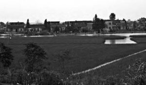
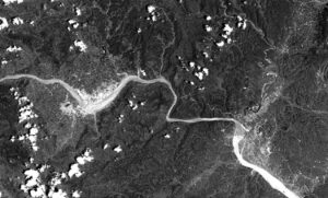
by rice fields near Poyang lake.
The largest cities in the lower Chang Jiang basin are located almost entirely within floodplains, and their development and growth depend upon the protection of levees, but there are many cases of levees around cities being overtopped or breached. Wuhan, the largest city along the lower Chang Jiang, flooded numerous times. E.L. Oxenham, who lived in Wuhan during the 1849 flood, noted that
. . . in the last and present century, many floods are recorded, but the highest one on record in modern times is that of 1849, when heavy and continuous rain appear to have fallen at the same time over the whole of the vast area of the provinces of Hu-pe, Hu-nan, and Sze-chuan (referring to Hubei, Hunan, and Sichuan Provinces in central China) . . . . The water rose with startling rapidity, sometimes as much as three feet (one meter) in a day, and the city was flooded to the depth of twelve feet (four meters), leaving little but roofs of houses above the water. Crops were everywhere destroyed and innumerable houses swept away.8
The 1848 and 1849 floods along the lower Chang Jiang were among the most severe in the nineteenth century. Because they occurred before hydrology recording stations were established, the exact water level is unknown. Both floods, however, were well documented in government reports. During the 1848 summer floods, many of the major levees along the Chang Jiang and its tributaries were overtopped, and large sections of the Chang Jiang alluvial valley were submerged by floodwater—sometimes several meters deep. According to a provincial government report, “deaths were countless.” The 1849 flood began during the early part of the next summer and water levels reached even higher levels than the previous year. Many of the levees destroyed during the 1848 flood had not been repaired, and low-lying areas were susceptible to floods well before the river reached peak stage. It is not possible to determine the number of deaths caused by these floods, but considering the large number of levee failures, the extent and depth of floodwater, and descriptions in government reports, deaths during both years may have measured in the tens of thousands and possibly higher.9
During the summer of 1931, the lower section of the Chang Jiang experienced a severe flood that is ranked as one of the world’s greatest natural calamities. The water level at the peak of the flood was the highest recorded since the Hankou hydrology station was established in 1865, and was almost certainly as high, or higher, than the 1849 flood. Most levees along the main channel of the Chang Jiang broke, and about 180,000 square kilometers (70,000 square miles) were flooded— an area about the size of New York, New Jersey, and Connecticut combined. The flood directly accounted for approximately 140,000 deaths throughout the Chang Jiang watershed. Millions of other people died shortly afterwards from starvation and disease. Although at the time the catastrophic nature of this event was well known, the flood’s severity seems to be forgotten both within China and the outside world. Both the British Naval Air Corps and American aviator Charles Lindbergh conducted aerial surveys to map the flooded areas, and the United States sent China 450,000 tons of wheat to assist the recovery.10
Wuhan also flooded during 1931 and 1954, with floodwaters in some sections of the city two to three meters deep. Another recent example is Jiujiang, a city with more than 500,000 people located on the banks of the Chang Jiang near Poyang Lake. During the 1998 flood, a sixty-meter section of the main levee broke, flooding the western sections of the city and its suburbs. (See Table 1.)
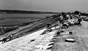
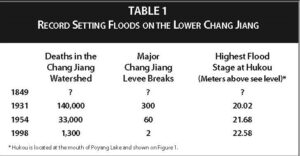 The next great flood occurred during 1954, when the peak water level at some points along the Chang Jiang was greater than 1.5 meters above the previous 1931 record high. At least sixty major levees located directly along the Chang Jiang were breached or overtopped and approximately 33,000 deaths in the watershed were related to the flood. When the river began to rise during early summer, some levees were opened in an attempt to lower the water level and relieve pressure. This effort was unsuccessful, and major levees throughout the region eventually broke or were overtopped. The 1954 flood had the highest water level recorded until the 1990s and is often used as a reference when discussing flood events. After the 1954 flood, China undertook an aggressive flood prevention policy that included new levee construction to protect additional low-lying areas that previously could not be cultivated, and improvement of existing levees to better withstand major floods. These levee projects continued into the 1990s (Fig. 5).
The last major flood on the Chang Jiang occurred during 1998, when the record water level along the lower section of the river exceeded the 1954 record by more than one meter, and many large tributaries had record high water levels. Hundreds of smaller, less important levees along both tributaries and lakeshores failed, including those along Poyang and Dongting Lakes. Nearly 1,300 people died as a result of the flood, and millions were evacuated to higher ground.11 Only two major levees on the Chang Jiang were breached, reflecting dramatic improvement in levee construction since 1954.
The 1998 flood was by far the worst on record, even though river discharge was lower than the 1954 flood. This was due, in part, to new levees being constructed directly on riverbanks and along lakeshores, which reduced the available area for floodwater storage in alluvial river valleys. The constriction of floodwater to a smaller area resulted in floods that—with equal discharge—have higher water-surface elevation.
INCREASING FLOOD RISK AND FUTURE PROSPECTS
Historically, the approach to dealing with Chang Jiang basin floods was to build levees; often, however, they were poorly constructed and too low to protect low-lying areas. This strategy resulted in repeated disasters. Recent levee construction on riverbanks and along lakeshores has reduced the available area for floodwater storage in the alluvial river valleys. This explains why the 1998 flood was by far the highest ever recorded, even though river discharge was lower than the 1954 flood. It also explains, in part, why the frequency and severity of floods has increased during the later half of the twentieth century. By placing levees close to lakes and riverbanks, they were positioned to protect as much of the rural population and agricultural area as possible. The rural population density on the alluvial plains ranges from 400-800 persons per square kilometer. The average amount of agricultural land per family is only about 1,500 square meters, and the crop production from these small farm plots is the primary source of income for many farmers. Placing levees farther from the lake and riverbanks would cause an abandonment of farmland that would force the relocation of farmers into areas already densely populated and in intensive cultivation.12
As the severity of floods increases, the Chinese government continues to refine its approach to dealing with this historic problem. In the past, levee construction was the primary approach to alleviating floods. Considering repeated levee failures, however, this approach was not entirely successful. In addition, building extensive levee systems increased flood height and often made matters worse. In the past ten years there has been a transition in the Chinese government’s approach to flood policies and planning priorities—moving away from flood control based on levee construction toward flood management practices.13 These management practices include opening some levees during major floods to lower the water level in lakes and reduce stress on other levees. This approach does not solve the problem completely, however, since only a small part of the reclaimed floodplain will be returned to the river. In addition, reduction in the floodwater storage area becomes problematic if rainfall patterns in the Chang Jiang basin match those that occurred during 1931 and 1954. The prospect of future catastrophic flooding along the Chang Jiang has diminished only slightly, and flood management will continue to be a high priority for the region.
- L. P. Van Slyke, Chang Jiang: Nature, History, The River (USA: Addison-Wesley Publishing, 1988).
- J. Z. Xu, Floods and Droughts in Jiangsu Province and Shanghai, Nanjing Institute of Geography and Limnology, Chinese Academy of Science, 1976 (in Chinese), V.B. Sauer, “Flood-frequency analysis with historical data in China” in Hydrologic Frequency Modeling: Proceedings of the International Symposium on Flood Frequency and Risk Analysis,V.J. Singh, ed. (Baton Rouge: Louisiana State University, 1986).
- Hu Xiying and Zhu Hongfu, “Three Gorges Dam project and flood protection of important cities in the Poyang Lake region,” Journal of Jiangxi Normal University 22,1998: 365–370 (in Chinese). Liu Xiaodong and Wu Dunyin, Brief analysis of the effect of the Poyang Lake water level in flood period by the Three Gorges Dam project, Jiangxi Hydraulic Science and Technology 25, 1999: 71–75 (in Chinese).
- G. X. Yang, “Dangerous Situation in Levees and Treatment Measures,” Chang Jiang River 30 1999: 13–15 (in Chinese). Li G.X., Jie Y.X., and Li Q.Y, Chang Jiang dykes and its strengthening. Lowland Technology International 5. 2003: 39–46.
- Q. Min, “Preliminary analysis of Poyang Lake’s relatively big flood occurrence characteristics during the past 500 years,” Jiangxi Hydraulic Science and Technology 18, 1992: 76–83 (in Chinese).
- Jiujiang County Government report, Jiangxi Province , 1849 (in Chinese).
- Poyang County Government report, Jiangxi Province , 1849 (in Chinese).
- E. L. Oxenham, “On the inundations of the Yang-tse-kiang,” Journal of the Royal Geographical Society 45, 1875: 170–184.
- W. Zhao, J. Zheng, Q . Ge, “The reconstruction of 1755 and 1849 severe flood events in Jiangsu and Anhui Provinces,” Scientia Meteorologica Sinica 24, 2004: 460–466 (in Chinese). Jiangxi Province County Government Reports (unpublished, 1849).
- Report of the National Flood Relief Commission, 1931–1932 (Shanghai: Comacrib Press, 1933).
- Dong Zhiyong, “On ‘98 extraordinary flood in Chang Jiang River valley of China,” Procedings of the International Association of Hydraulic Engineering and Research (Graz, Austria, 1999), D. Shankman and Q. Liang, “Landscape changes and increasing flood frequency in China’s Poyang Lake Region,” Professional Geographer 55, 2003: 434–445.
- Su Shonde, Zhou Weigong, and Tan Huirn, eds., Poyang Lake Atlas, Jiangxi Provincial Science Academy, China Science Academy (Nanjing Geography and Lake Research Institute, Jiangxi Provincial Government Mountain, River and Lake Development Committee, Scientific Press. 1993), in Chinese, Shankman and Liang, 2003.
- Zhao Xiaomin. Jiangxi Province Landuse General Plan: 1997–2010 (Preliminary Draft), (Nanchang: Jiangxi Provincial Government Publication, 1999), (in Chinese). Chen Xiaotao, “Recent progress in flood management in China,” Irrigation and Drainage 55, 2006: 575–582.